 NAUTICAL NAVIGATION & FLEET OPERATIONS • DEMO VERSION 2.0
 Smart Nautical Navigation &
Connected Fleet Safety
Designed from the keel up for navigators, charter companies, and commercial boat fleets. GeoPointer unifies high-resolution bathymetric cartography, live AIS traffic awareness, and rapid emergency coordination into a single, reliable marine cockpit.
Tested on 100+ outings • No proprietary hardware lock-in • Works online & offline
THE OPERATIONAL DIFFERENCE
Engineered for the Unpredictable Realities of Water
Generic automotive road maps fail at sea. GeoPointer delivers purpose-built tools that keep vessels safe, visible, and coordinated.
Precision Under-Keel Safety & Depth Awareness
Navigate confidently in shallow channels, rocky bays, and dynamic shorelines.
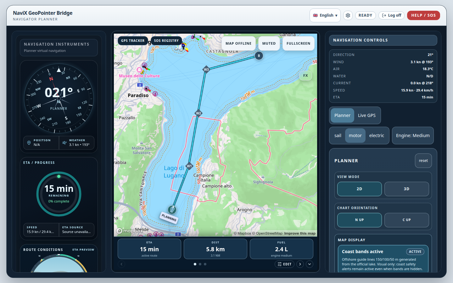
GeoPointer integrates official high-precision bathymetric models (such as swisstopo SwissBATHY3D) directly into intuitive vector charts. Dynamic depth shading and under-keel clearance alerts warn skippers before grounding hazards become emergencies.
- • Progressive depth contours (2m, 5m, 10m, 20m, 50m)
- • Customizable vessel draft grounding safety buffer
- • Works seamlessly offline with lightweight vector tiles
Live Situational Awareness & Collision Prevention
Track surrounding vessel traffic with instant Closest Point of Approach (CPA).
Real-time AIS vessel ingestion maps commercial ferries, passenger craft, and recreational traffic directly onto your helm display. Projection vectors highlight potential crossing hazards before they become critical.
- • Real-time vessel classification, heading, and speed
- • Visual collision warning vectors
- • High-contrast day and scotopic night vision modes
Connected Incident Command & Fleet Coordination
Transform emergency panic into structured, accountable assistance.
In the event of an incident or breakdown, GeoPointer provides instant atomic GPS coordinate locking and telemetry relay. Fleet operators see approaching responder craft, live bearings, and accurate ETA countdowns in real time.
- • Instant access without credential lockout
- • Simultaneous tracking of distressed and assisting vessels (2nd-position telemetry)
- • Real-time approach vector and range calculation
See GeoPointer in Action on Lake Lugano
Follow the complete workflow between two distinct vessels on Lake Lugano: 100% water-only route navigation, SOS initiation ("Man overboard"), second vessel alert reception ("Partecipa al soccorso"), water-only rescue approach with live ETA, on-scene arrival ("Sul posto"), and audited resolution.
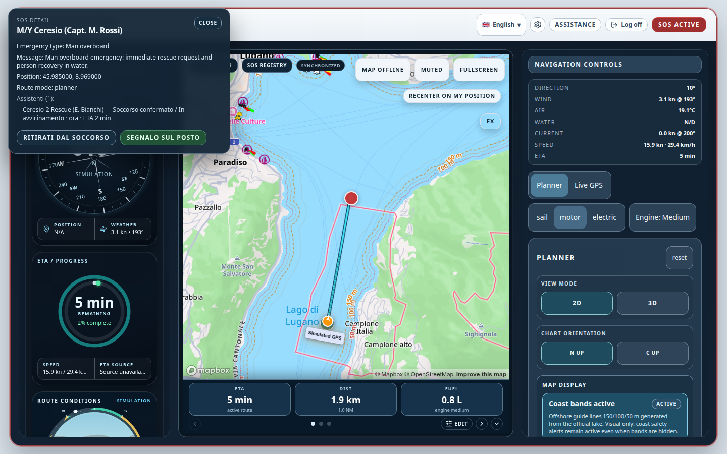
Shared SOS Assistance & On-Scene Resolution
Complete end-to-end workflow between two distinct vessels on Lake Lugano: SOS initiation ("Man overboard"), second vessel alert reception ("Partecipa al soccorso"), water-only rescue approach, "Segnalo sul posto" arrival, and "Risolvi SOS" closure.
On-Water Outings
in Switzerland and Italy
Developed on the water. Refined through experience.
More than 100 on-water outings in Switzerland and Italy have helped us refine GeoPointer through practical use.
Working with nautical partners and drawing on their experience and support, we have tested the software in real navigation conditions, across private boating and public navigation contexts.
These outings have helped us observe the software in everyday use, identify issues and improve navigation, interface usability and connected safety workflows.
Our approach is straightforward: test on the water, learn from experienced users and continuously improve the product.
Compliance note: the testing described reflects practical field development and does not constitute formal certification or a claim that every feature is fully validated under all marine conditions.
CAPABILITY MATRIX
Transparent Technical Capabilities & Roadmap
We clearly differentiate between verified operational capabilities, features currently in active field validation, and upcoming roadmap items.
High-Precision Bathymetry
Sub-meter depth models for Swiss Alpine lakes and coastal shelves with dynamic safety shading.
Vector Cartography & Offline Cache
Fast vector tiles and local PMTiles caching for uninterrupted navigation beyond cellular reach.
Multi-Waypoint Route Planning
Theta* marine routing engine calculating collision-free waterway passages around shallow banks.
Emergency Assistance Workflow
Client-to-operator coordinate lock, telemetry dossier generation, and approaching responder ETA.
Central Fleet Operator Portal
Multi-craft simultaneous radar tracking and geofenced speed alerts currently under pilot testing.
Marine Hardware NMEA Bridge
Native NMEA 0183 / 2000 sensor integration for fixed helm electronics and onboard wind transducers.
Compliance notice: GeoPointer is a situational navigation aid and fleet coordination tool. It does not replace official statutory SOLAS charts or certified marine VHF radio equipment.
Empower Your Boat Charter & Rental Fleet
Designed for boat rental companies, charter operators, sailing academies, and water taxi fleets on Lake Lugano and Lake Maggiore.
Automated Geofencing & Shallow Alerts
Keep rental customers out of hazardous shoals, private reserves, and national border boundaries automatically.
Live Central Dispatch Radar
Track every active boat simultaneously from your harbor office. See exact battery/fuel burn, speed, and ETA.
One-Touch Client SOS Support
If a customer runs aground or experiences engine failure, your base receives immediate telemetry and GPS coordinates.
Fleet Console Architecture Fleet Operator Specifications
CONNECT WITH NAVIX
Ready to Transform Your Vessel or Fleet Operations?
Whether you manage a commercial charter fleet, operate a sailing academy, or require customized nautical cartography, our team is ready to discuss how GeoPointer can meet your requirements.
Request a Demonstration
Experience the live web cockpit and emergency coordination workflow directly with our engineering team.
Discuss a Collaboration
Partner with NaviX for specialized nautical integrations, fleet telematics, or custom lake and coastal bathymetry.
Inquiries are routed directly via email to the project core team at platform@navix-app.com. Zero commercial tracking, zero spam, and zero third-party resale.